Details
Easiest way to get there is thru Mayer, AZ. off Hyw 69 to Prescott.
Where is a Circle-K in Mayer. From the Circle-K take Central to a left on Miami. From Miami take a right on Main St. Just past the Double D Bar on Main St., take a left on Wilks. At the three way junction at the end of Wilks, take Jefferson, which is the Goodwin Road.
The Goodwin Road intersects the Senator Hyw about half way between Prescott and CK. It’s about 25 miles of dirt road.
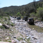
Take a left onto Senator Hyw, stay on it for approx 4 miles and turn left onto FS 89. It goes thru a burned off area, decends a hill and crosses a large wash. Turn left into the wash and have a good time! Once thru the rocky sections, both of which are relatively short, you climb over a ridge or two until you get to the next major wash at the Goat Ranch. From there, the trail goes up the the Peck Mine Road. This appears to be the main road, but the DeSoto trail is a very sharp turn to the left. If you cont. out to the Peck Mine you intersect the main road to CK and miss all the hill climbs and the mine itself.
There are two cattle ponds on this section. They probably have water in’m. Prior to the second pond you have the option of going out via the “official” route in Charles Well’s book, or heading up to the DeSoto Mine. There is a faint left turn off the main trail prior to the pond – that leads to some VERY VERY interesting off camber sections. I had my wheelin’ buddy hang off the high side as a counter weight thru one spot- the body roll made it feel alot worse than it is, but looking out the drivers door down 45 deg angle at steep hillside always gives me the puckers
If you proceed on to the pond itself, the trail goes up and over the top of the ridge. The route can be very confusing at this point due to a bunch of mine roads branching off the main road. Stop at the top and explore, it offers some great veiws. The main mine is to your right on top of the hill. Once you cross the top, the trail leads down to a large flat section and the main road is bunkered off. If you look to the left edge of the brush on the flat section, you will find a steep decent down to a mine shaft- that is the way out of the maze. Follow that road out to the CK road – you come out above Cleator by a few miles.
If you have the time and want to see some more neat country, take a left at Cleator on the old railroad bed cut just east of the Cleator Bar. It will take you back to Mayer once it intersects the Old Cordes road.
Lots of varied terrain with great veiws and a ton of history. You pass close to one of the more famous Apache vs. Miner fights in the old west. Battle Flat is a great story of survival and outright toughness.
Location
Address: