ByPierre LeBlanc
June 22, 2020
0
Details
Venue Website: https://www.sunwestfcu.org/
Location
Address:11839 N 28th Dr, Phoenix, 85029, United States

Venue Website: https://www.sunwestfcu.org/
Venue Website: http://www.hiltonelconquistador.com/
Tucson is surrounded by five mountain ranges and our resort rests in the shadow of the Santa Catalina Mountains under the warm southwestern sun. What makes the city so special is that despite being a growing metropolis, it still retains its friendly, typically Arizonan, western charm. Discover 19th century architecture or visit local Tucson attractions like Tohono Chul Park, Catalina State Park or Biosphere 2.
Delve into the wonder of the natural world at Arizona-Sonora Desert Museum, enjoy a narrated tram ride through the Sabino Canyon or hike one of the many trails at Saguaro National Park. And don’t forget, however you choose to spend your visit, our Concierge team will be delighted to assist and ensure your stay is unforgettable.
Follow interstate 10 and exit onto Tangerine Road heading east. Turn right at Oracle Road heading south and continue 3 miles to El Conquistador Way. Turn Left and the Resort is on your right.
Getting There
From Tucson International Airport
Distance from hotel: 23 miles
Drive time: 30 – 45 mins
Follow interstate 10 west to Ina Road. Exit Ina Road, turn right and head east to Oracle Rd (about 5.3 miles). Turn left onto Oracle Road (north) and continue 2.5 miles to El Conquistador Way. Turn right and the Resort is on your right.
From Phoenix Sky Harbor International
Distance from hotel: 100 miles
Drive time: 1h 30mins
Exit airport and follow signs to interstate 10 east to Tucson. Exit right off of I-10 and make a left hand turn onto Tangerine Road, follow Tangerine Road to Oracle Road (13.5 miles), turn right onto Oracle Road. Turn south on Oracle Road 3.76 miles to El Conquistador Way. Turn left and the Resort is on your right.
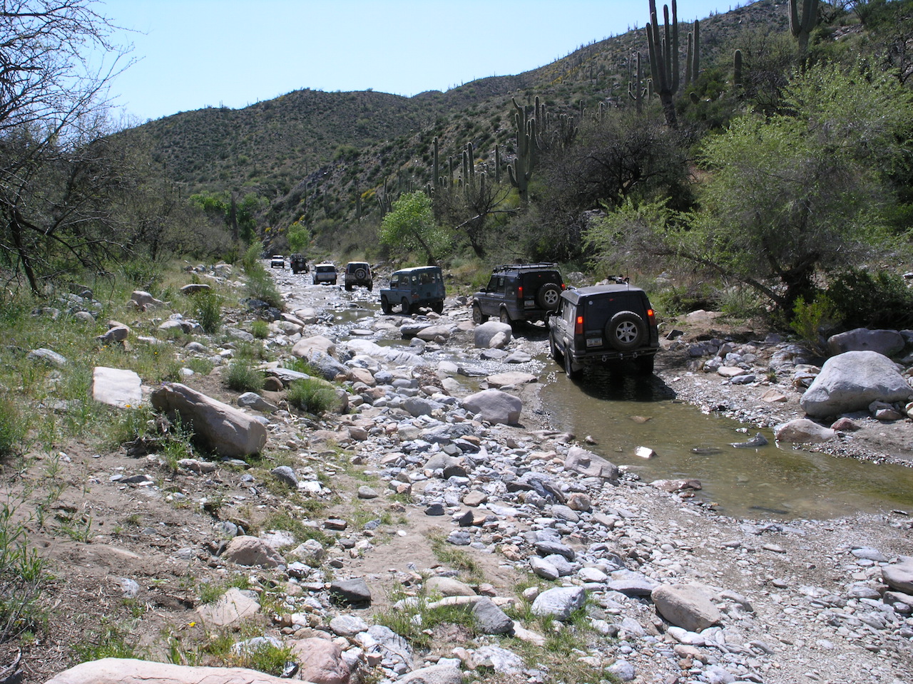
This hidden gem is not listed an any guide books. You’ll enter the trail from Bill Grey and buckboard trail and follow a power line road up through some fanstastic red rock country. Several rock shelves and washed out areas will be sure to flex your springs a little and test your traction where the rubber meets the rock.
19 miles
A short exctiting challenge. This trail can also be run in reverse.
5 miles
Bill Grey and Buckboard roads lead to the trailhead for Sugarloaf mountain trail. This easier moderate trail leads to the top of sugarloaf mountain and to a gated mine, with a return trip back on the same trail to Bill Grey Rd. Two overlook areas near the top offer spectacular views across the valleys, this is an excellent spot to break for lunch. A trip back to town passes by Tuzigoot National monument which is an optional stop.
34 milesHighlights: Very remote location, exceptional vistas, lots of wildlife
Near: Safford, AZ
Distance: 10.78 miles round trip
Elevation Gain: 2942 ft
This trail was described in The Arizona Republic as ‘one of the prettiest drives you’ll ever take’. The trail begins at the base of Salt River Canyon, where US-60 crosses the Salt River northeast of Globe. The trail begins with the outstanding scenery of traveling along the bottom of the Salt River Canyon, a feeling of being inside a mini Grand Canyon. We will splash through Cibeque Creek where it meets the Salt River, and work our way west toward the Rock Canyon grotto, which may be seeping water if there has been enough precipitation. Lunch likely will be along Gleason Flats, which offers a wide view of the valley and the Salt River below. The trail finishes through Cherry Creek road and wonderful views of the Sierra Ancha mountains, and finally connects with State Route 288.
Note: This trail begins on the Fort Apache Indian Reservation, and requires that each vehicle purchase a day permit for $5.00.This is a moderate trail and any stock Land Rover is capable of handling this trail.
We will meet in Florence and follow the road that parallels the Gila River. Then we turn north into Box Canyon. The canyon is very scenic and is very narrow in sections. This section of the trail is fairly easy but there are several moderate sized rocks to get over. After the canyon we make our way to the Coke Ovens. This part of the trail is long and there are many obstacles encountered like steep climbs, rocky steps, and other challenging rock obstacles. However, there are challenges for everyone! We will have lunch at the Coke Ovens which are huge beehive shaped ovens. After lunch we make our way back track about a mile up the ridge and descend towards the Gile River and follwo the trail out towards White Canyon Wilderness. this section of the trail has suffered from heavy rain errosion over the past year but is still very passable. We end the day where Battle Axe Road meets Highway 177 just south of Superior.Easiest way to get there is thru Mayer, AZ. off Hyw 69 to Prescott.
Where is a Circle-K in Mayer. From the Circle-K take Central to a left on Miami. From Miami take a right on Main St. Just past the Double D Bar on Main St., take a left on Wilks. At the three way junction at the end of Wilks, take Jefferson, which is the Goodwin Road.
The Goodwin Road intersects the Senator Hyw about half way between Prescott and CK. It’s about 25 miles of dirt road.
Take a left onto Senator Hyw, stay on it for approx 4 miles and turn left onto FS 89. It goes thru a burned off area, decends a hill and crosses a large wash. Turn left into the wash and have a good time! Once thru the rocky sections, both of which are relatively short, you climb over a ridge or two until you get to the next major wash at the Goat Ranch. From there, the trail goes up the the Peck Mine Road. This appears to be the main road, but the DeSoto trail is a very sharp turn to the left. If you cont. out to the Peck Mine you intersect the main road to CK and miss all the hill climbs and the mine itself.
There are two cattle ponds on this section. They probably have water in’m. Prior to the second pond you have the option of going out via the “official” route in Charles Well’s book, or heading up to the DeSoto Mine. There is a faint left turn off the main trail prior to the pond – that leads to some VERY VERY interesting off camber sections. I had my wheelin’ buddy hang off the high side as a counter weight thru one spot- the body roll made it feel alot worse than it is, but looking out the drivers door down 45 deg angle at steep hillside always gives me the puckers
If you proceed on to the pond itself, the trail goes up and over the top of the ridge. The route can be very confusing at this point due to a bunch of mine roads branching off the main road. Stop at the top and explore, it offers some great veiws. The main mine is to your right on top of the hill. Once you cross the top, the trail leads down to a large flat section and the main road is bunkered off. If you look to the left edge of the brush on the flat section, you will find a steep decent down to a mine shaft- that is the way out of the maze. Follow that road out to the CK road – you come out above Cleator by a few miles.
If you have the time and want to see some more neat country, take a left at Cleator on the old railroad bed cut just east of the Cleator Bar. It will take you back to Mayer once it intersects the Old Cordes road.
Lots of varied terrain with great veiws and a ton of history. You pass close to one of the more famous Apache vs. Miner fights in the old west. Battle Flat is a great story of survival and outright toughness.
The route starts out in the low desert and continues into the upper elevations of the Superstition Mountains where it tops out at about 5200 feet above sea level. The higher elevations are on the northern slopes and offer the piney vegetation typical throughout the southwest. The climb to the elevations occurs along a series of switch backs that allows an impressive view of surrounding countryside. Stock vehicles with high ground clearance and good articulation can make it although some driving skill is necessary.